Use www.mapy.cz to Generate Online Prague Maps
This guide shows you how to generate different types of online Prague maps (pictorial, historical, transport, interactive and aerial photographic) and find where you’ll be staying. It also shows you how to use the integrated search function and route planner.
NOTE: For this example I’ve used Wenceslas Square (Vaclavske Namesti) as the central starting point where you can still see the New Town, Old Town, Lesser Town and Castle areas and you can drag the map as required.

The Basic Online Prague Maps
Go to the STARTING POINT MAP.
This is the default map type (zakladni) and shows metro stations, tram stops, bus stops, railway stations, main roads, museums, tourist information points, post offices. Note that some icons are “dead” i.e. just pictures but others are “live” i.e. can be clicked for more information. You can find tram line number info on Prague maps at this level.
On the top right of the page is a “-+”. Use + to zoom in and – to zoom out. Zooming changes the map in the following way:
1) If you zoom in once then as well as the icons previously, additional icons will appear like popular Jewish sites, shopping centres, restaurants and car parks (non-detail version).
2) If you zoom in again you get additionally: street directional and name info, building numbers, chemists, theatres, cinemas, some restaurants, some hotels, embassies and car parks (detail version). Note that most icons are clickable in this view to find pictures and weblinks.
3) If you zoom in again (this is the MAXIMUM ZOOM) you get additionally: All hotels, all restaurants, Palace info, cafes, bankomats (ATMs) and some public toilets.
Now the issue with zooming to detail is that you might have gone away from where you wanted to see. Mapy.cz online Prague maps can be “dragged” i.e. depress the left mouse button and use the mouse to drag the map in the direction that you want. If in doubt, use the “-” zoom out button.
Changing Online Prague Maps Type
On the top left of the page is a button called “zmenit mapu”. Click this and you’ll get a choice of online Prague maps as I describe below:

The view with the green tick is what you are currently looking at. If you have dragged the map away from it’s original position then the new map type will reflect the new position.
Turisticka: The Tourism map is very similar to the basic map but with the addition that many of the buildings are now named and it shows restaurants, hotels and museums.
Fotograficka: The Photograph map looks similar to the Tourism map but does NOT show hotels or restaurants. It keeps the building names and shows photographs taken from different locations.
Dopravni: The Transport map strips out everything except building numbers, street names, directional info, car parks and traffic flow.
Letni: The Summer map is more useful outside the city where it will show “Summer-only” facilities like campsites, outdoor recreation and outdoor swimming locations.
Zimni: Same format as the Summer map but this time for “Winter-only”.
Letecska: The Satellite Prague maps show aerial photographs of the city and have archived versions from previous years so you can see how an area has developed.
Z 19 Stoleti: The 19th Century map is very interesting if you are familiar with Prague’s geography. Major landmarks are visible including the main railway station which at that time was on the edge of the city.
Hapticke: Prague maps for the blind showing the street names can be printed so long as you have a Braille printer. The “mapa” screen is made up of a grid. Switch to the “Tabulka” version to see the grid numbers and tick the box for the area that you want. Then print that area.
The Satellite/Hybrid Online Prague Maps Function
On the top left of the page is a “Z Letadla” option (from the plane) which does two things. Firstly it switches you straight into the latest satellite view. Secondly it adds street names so it acts as a “hybrid” map i.e. photography and street map however it contains no building, traffic or tourism info. You will find this option very useful if you use it combined with the Panorama function below.
The Panorama Online Prague Maps Function (Interactive)
On the top left of each map type (except Hapticke) is a button called “Panorama”. Clicking this button causes all vehicle accessible streets to show a red line. This is the same as Google maps “street level” with the exception that you click on the part of the line that you want to see. The photo will appear on the right side of the screen. Page control functions are the same as Google Maps in that you can advance by clicking on the photo or drag to turn it.
The 3D Online Prague Maps Function
On the top left of the page is a “3D Pohled” option (3D view) but it currently only functions for the “Letecka” Prague maps type.
Right-screen Functions
If you started with the basic online Prague maps type then you may have a full-screen map. If you look on the right of the map you’ll see a small inward facing arrow. Click on this arrow to expand the section and you’ll have the options shown.
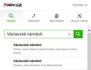
Hledani: The search function is extremely useful so long as you input the exact name of the street that you are looking for in Czech i.e. in this example if you had input “Wenceslas Square” you would have got nothing. Instead you must enter “Vaclavske Namesti”. The system is smart enough to recognise the name without using Czech characters and it will give you a choice of locations throughout the country. Look for the one that says “Hlavni Mesto Praha”.
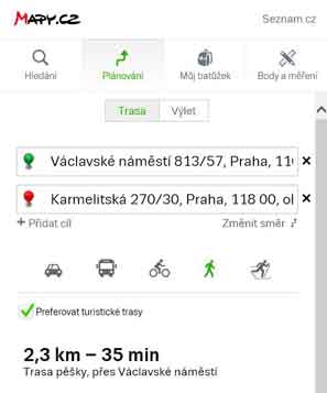
Planovani: The other very useful Prague maps option is the track planner. By selecting this option you will have some additional choices to make. Firstly the Planner assumes that you are driving and gives you options for “Nekratsi” (shortest) or “Nerychlejsi” (fastest) route so if you are walking then select the icon showing the walking man. To select your start point you move the mouse to the desired position and “plant” the green pin. This will put an address in the top box. Then find your destination and plant the red pin. This will put an address in the bottom box. It then calculates the distance and time required.
So hopefully you’ll now be able to explore all the online Prague maps and have fun.
My Own Guided Tours – Cheaper Than You Think!